A Night Turned to Chaos
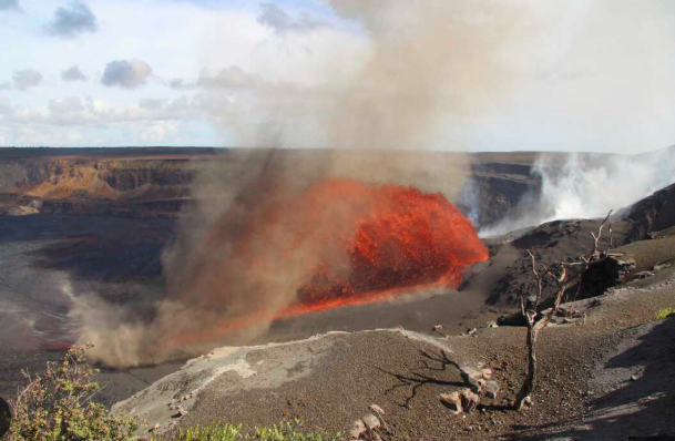
On June 21st, 2025, the sky over Guatemala didn’t darken from nightfall—it turned pitch black as Fuego Volcano exploded without mercy. Within seconds, pyroclastic flows raced downhill at 100 km/h, swallowing villages, homes, and roads in their path. Ash clouds surged 7 kilometers into the atmosphere, forcing flights to reroute while the world watched in horror.
The air turned poisonous, and thousands evacuated as emergency sirens wailed across cities. But for many, it was already too late. Live satellite images showed rivers of fire slicing through farms and forests, while survivors described it as a dragon awakened—unstoppable, brutal, and silent until it struck.
Why This Eruption Was Different
Scientists from INSIVUMEH, the Guatemalan volcanology institute, confirmed Fuego had entered a high-intensity explosive phase, hurling lava bombs in multiple directions. Unlike past eruptions, this wasn’t a slow buildup—it was a sudden shift, cracking the earth’s surface with powerful internal tremors.
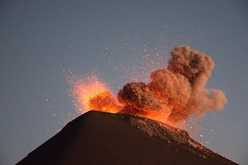
Local cameras captured eerie images: molten rivers cascading down ravines, explosions every few seconds, and ash plumes drifting toward densely populated zones. Meteorological radar tracked the ash cloud drifting west, threatening Escuintla, Chimaltenango, and Sacatepéquez with heavy ashfall. By sunrise, entire towns were buried under volcanic debris.
The Deadly Legacy of Fuego
Volcán de Fuego—literally “Volcano of Fire”—has a history of destruction. Its most devastating modern eruption in June 2018 buried the village of San Miguel Los Lotes, killing 200 people. Now, survivors fear a repeat as 2025’s eruption follows the same deadly pattern.
What makes Fuego so dangerous isn’t just lava—it’s the speed, silence, and unpredictability of its pyroclastic flows. These hot mixtures of gas, ash, and rock move at 100 km/h, killing everything in their path in under a minute. Satellite thermal imaging confirmed multiple flows on the southern and southwestern flanks, leaving 100,000 people in the volcano’s shadow scrambling to escape.
The Human Toll
Evacuation orders went out immediately, but chaos took over. Families fled in pickup trucks, tuk-tuks, or on foot, desperate to outrun the ashfall. Highways clogged with panicked traffic, while Rescue teams battled low visibility and treacherous terrain. In Alotenango and San Pedro Yepocapa, pyroclastic flows crept dangerously close to inhabited zones, forcing people into shelters in schools and churches.
But supplies ran short, and overcrowding turned tense. The government declared a national emergency, with NASA, USGS, and the European Space Agency tracking the plume in real-time. Pilots reported ash particles at 20,000 feet, risking engine failure and forcing cancellations at Guatemala City airport.
The Hidden Crisis
Beyond the destruction, a quieter crisis emerged: volcanic contamination. Ashfall blanketed thousands of acres of coffee plantations, cornfields, and livestock pastures, destroying harvests overnight. Farmers dug through gray dust with bare hands, but volcanic ash—razor-sharp and acidic—poisons water supplies and suffocates plants.
For survivors of the 2018 eruption, this was a haunting replay. Children in shelters cried, terrified the mountain would erupt again at night, while mental health counselors noted signs of PTSD. The invisible scars run deep—volcanic events shake the human soul, not just the ground.
What Comes Next?
As of June 22, volcanologists monitor Fuego closely, warning of secondary eruptions, lahars, or more lava flows. Drone footage shows cracks expanding, vents steaming, and the crater still glowing—signs this eruption isn’t finished.
For Guatemala, a volatile region, this is a wake-up call. Better warning systems and evacuation planning could mean the difference between survival and catastrophe next time.